Saildrone Surveyor: Redrawing the Map of the Deep Ocean
The world’s oceans remain, in many ways, the last great frontier. We know more about the surface of Mars than we do about the seabed that covers over 70% of our planet. Despite decades of naval exploration, less than a third of the global ocean floor has been mapped to modern standards. The challenge is immense: the ocean is vast, remote, and expensive to survey. Yet one company believes it has the answer—by deploying fleets of autonomous, renewable-powered vessels that can stay at sea for months at a time without the need for crews or constant resupply.
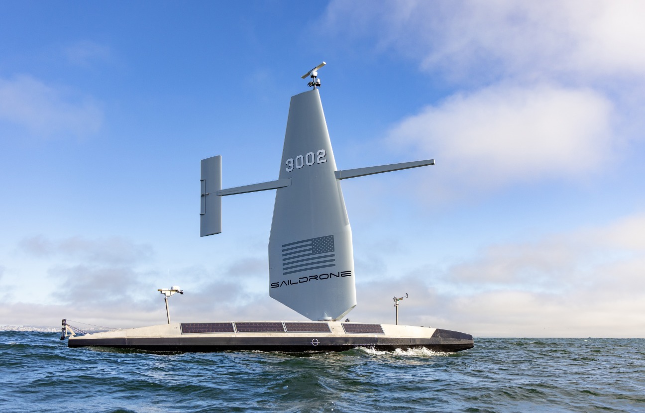
Saildrone, a California-based pioneer in uncrewed surface vehicles (USVs), has been operating fleets of wind- and solar-powered craft for over a decade. Best known for their smaller Voyager-class drones, used for coastal monitoring and fisheries research, the company is now turning its attention to the deep sea with its flagship Surveyor vessel. At 22 metres long, the Surveyor is significantly larger than its coastal cousins and is equipped to take on the monumental task of mapping the world’s oceans.
“The basic technology is the same between the three classes, the wing is the key to providing extremely long endurance, measured in months, not days, but the size does change the power load and, therefore, the capabilities,” according to the company. “The Surveyor carries multibeam sonar for deep ocean mapping. It can also tow acoustic arrays for undersea surveillance, and the height of the wing gives us an exceptionally long range on the radar and cameras. The Voyager is optimised for coastal surveillance and carries multibeam sonar for ocean mapping up to 300 metres deep.”
Surveying the Unknown
Traditional ocean survey vessels are large, crewed ships that can cost hundreds of thousands of dollars per day to operate. They consume fuel at a prodigious rate and often need to return to port for maintenance and resupply. By contrast, Saildrone’s Surveyor can remain at sea for months at a time, powered primarily by wind, supported by solar panels, and backed up by a small diesel generator when conditions require. This combination of endurance and autonomy is what sets it apart.
Across all classes, the sensors carried by Saildrone’s vehicles are “in most cases, exactly the same as traditional survey, research, and/or navy vessels,” according to the company. The difference lies not in the quality of the data, but in the cost, scale, and sustainability of collecting it. With no crew on board, operating costs are dramatically reduced, while the use of renewable energy makes long-term missions both feasible and environmentally friendly.
The Surveyor’s mission profile is straightforward: systematic, routine mapping of the seafloor. “It’s like mowing the lawn,” the company explained. The drone sails along a carefully defined route, collecting high-resolution sonar data of the seabed below. If an area of interest is detected—say, a geological feature or a potential resource—then a crewed ship with more specialised equipment such as remotely operated vehicles (ROVs) can be sent to investigate. In this way, Surveyor acts as both a scout and a workhorse, filling in the many gaps in our understanding of the ocean.
Autonomy, With a Human in the Loop
The word “autonomous” is often associated with machines that make decisions entirely on their own. In practice, Saildrone’s approach is more measured. “The Surveyor sails fully autonomously, but it is navigated by Saildrone Mission Control,” according to the company. “That is, we give it a waypoint and a corridor, and it sails autonomously in that corridor to that waypoint. It cannot autonomously decide where to go, only how to execute a route plan.”
This model ensures safety and predictability while still leveraging the efficiency of automation. Mission Control, based in California, oversees the drones’ progress and can adjust routes as required. The Surveyor itself takes care of the fine details—sail trim, steering, energy management—without human intervention. The result is a vessel that can operate safely and productively for months at a time, far from land.
From Platform to Service
One question for any emerging technology company is whether to focus on selling hardware or services. Saildrone’s answer is clear. “Saildrone is a data provider. We do not sell the saildrones, we operate on a ‘mission as a service’ model,” according to the company. “The customer tells us what data they want, and we deliver it to them, supporting end-to-end logistics and mission management.”
This model has two advantages. First, it allows customers—whether governments, navies, research institutions, or commercial operators—to avoid the complexities of owning and maintaining a new type of vessel. Second, it ensures that Saildrone can operate at scale, standardising operations across a fleet that it controls directly. For a technology still in the early stages of adoption, this level of control is crucial.
Reaching Classification Standards
A milestone for Saildrone came with the recent announcement that its Surveyor-class vessels have achieved full classification from the American Bureau of Shipping (ABS). For the uninitiated, classification is a rigorous process in which an independent body verifies that a ship meets strict safety, construction, and operational standards. In the world of crewed ships, classification is routine. For uncrewed vessels, however, it remains rare.
“Many commercial contracts, and increasingly, defence contracts, require ABS class or similar,” according to the company. “For example, ABS standards are referenced in the Navy’s engineering and qualification process, often specifying that USVs comply with ABS standards and are US-constructed. The successful construction of Saildrone Surveyor-class vehicles at a US shipyard, achieving ABS Classification, demonstrates our ability to build to Class standards through an external build process.”
Most USV developers, the company added, “are still at the prototype or demonstration stage, where certificates or MOUs are more achievable and appropriate. By contrast, Saildrone’s fleet has accumulated millions of miles and years of continuous operations at sea, proving a level of maturity and reliability necessary to satisfy ABS’s full review. In many ways, classification sets the bar that all USVs will ultimately need to reach if they are to be trusted for real-world operations.”
This certification not only boosts Saildrone’s credibility but also opens the door to new commercial and defence contracts that would otherwise be inaccessible.
Scaling Up
With classification achieved, the company is now turning its attention to scale. “In the coming months, Saildrone will be rapidly scaling up production to meet global demand across use cases,” according to the company. The demand is indeed global: seabed mapping is a priority for scientific research, climate monitoring, undersea infrastructure, and national security. The opportunity extends beyond mapping into fisheries management, maritime domain awareness, and environmental monitoring.
The Bigger Picture: Mapping the Ocean
The urgency of this mission cannot be overstated. The Seabed 2030 project—a United Nations-backed initiative to map the entire ocean floor by 2030—recently announced that only 27.3% of the ocean has been mapped to modern standards. “This is just one illustration of how little we know about the ocean,” the company noted. “As Saildrone continues to iterate and improve our platforms, we expand our capabilities and therefore data offerings to help fill the many gaps in knowledge and awareness of activity at sea.”
The stakes go far beyond cartography. A better understanding of the seabed has implications for everything from undersea cables and offshore wind farms to earthquake prediction and marine biodiversity. For navies, it provides critical situational awareness. For the scientific community, it unlocks insights into ocean currents, ecosystems, and climate change.
Looking Five Years Ahead
Asked to look forward, Saildrone sees its role growing in lockstep with the demand for ocean data. As autonomous technology matures and regulatory frameworks evolve, the company expects renewable-powered, crewless survey vessels to become a standard part of the maritime toolkit. The Surveyor, in this vision, is not just a vessel but a symbol of how autonomy and sustainability can converge to tackle one of humanity’s biggest knowledge gaps.
Conclusion
For most people, the ocean remains an abstract expanse—blue on the map, remote in daily life. Yet beneath that surface lies a landscape as varied and complex as any on land. By deploying fleets of Surveyors, Saildrone hopes to bring that hidden world into view, not with the roar of diesel engines but with the silent pull of the wind and the steady charge of the sun.
If successful, the company’s approach could transform not just how we see the ocean, but how we understand our planet.